
Observing Systems Simulation Experiments using
the NCEP data assimilation system
Principal Investigator: Stephen J. Lord
NOAA/NWS/NCEP/EMC
http://www.emc.noaa.gov/research/osse
1. INTRODUCTION
The future National POES System (NPOESS) is scheduled to be launched during the 2008-2018 period. For the next 10 years, a considerable amount of effort must take place to define, develop and build the suite of instruments which will comprise the NPOESS and its forerunner, the NPOESS Preparatory Program (NPP). The forecast impact of these future instruments must be assessed with experiments using simulated observations. These experiments are known as Observing System Simulation Experiments (OSSEs). (Lord et al. 1997, Atlas, 1997)
An OSSE system has been constructed through a collaboration between the National Centers for Environmental Prediction (NCEP), NASA/Data Assimilation Office (DAO), Simpson Weather Associates (SWA), and the National Environmental Satellite, Data and Information Service (NESDIS). Using OSSEs, current operational data assimilation systems can be prepared to handle new data in time for the launch of new satellites. Preparations include the handling of future data volumes, and the development of a data base, data processing (including formatting) system, and a quality control system. All of this development will accelerate the operational use of data from the future instruments.
To date, the major effort in this project has been to develop a simulated prototype Doppler wind lidar (DWL) data set. SWA has been able to simulate line-of-sight (LOS) winds using their Lidar Simulation Model (LSM). Bracketing sensitivity experiments have been performed for various DWL technology neutral concepts to bound the potential impact (Emmitt 1999, Emitt et al. 2001b). Scanning and various data sampling strategies were tested with these experiments. Analysis and forecast impacts of DWL were presented in Masutani et al. (2002b).
2. EVALUATION AND ADJUSTMENT OF THE NATURE RUN
The NR, a true atmosphere for OSSEs, needs to be sufficiently representative of the actual atmosphere and different from the model used for the data assimilation. In calibration, the observational data for existing instruments is simulated from the NR. Then forecast and analysis skill for real and simulated data are compared.
The Nature run period was found to be relatively neutral as ENSO event. intraseasonal oscillation was decaying during the NR period. Number of cyclone in ECMWF analysis is about 10% more than the NR run, which is within natural variability. Distribution of cyclone tracks are very realistic.
Sea surface temperature (SST) is fixed as SST on February 5th, 00Z throughout the period for the NR. The effect of the constant SST on the data has been evaluated. It is shown that OSSE with the constant SST will give a valid data impact while SST variability is small.
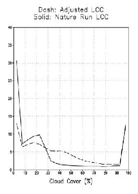
Cloud evaluation is particularly important for the assessment of Doppler Wind Lidar (DWL). DWL data can be retrieved only if DWL sample reach a target and the signals from target are able return to the satellite. The clouds are important targets for DWL and they also interfere with the DWL shot. Therefore, large differences in NR cloud amount will affect the sampling of simulated data. Realistic clouds are also necessary for generating realistic cloud track winds from geostationary platforms. The cloud distribution also affects the simulation of the radiance data as well.
In general, the NR total cloud agrees with observational estimate except over the North and South poles. All over the globe, the High level cloud cover (HCC) looked larger than the satellite observed estimate. The low level cloud cover (LCC) over the ocean is less than the observation and amount of LCC over snow is too high. After careful investigation, we found that due to the lack of reliable observations, there is no strong evidence for an over-estimation of HCC and polar cloud by NR. However, under-estimation of low level stratocumulus over ocean and over estimation over snow is inevitable and adjustments were applied.
Since satellite-based estimates have difficulty in sensing the low level cloud, the Warren (1952-1981), ground -based, stratus and stratocumulus climatology and vertical velocity from NR are used for adjustment. In lower levels, Warren cloud climatology is added if there is rising motion. Low level cloud is divided by 1.5 where there is snow cover over land. This adjustment made the cloud distribution much more realistic. Fig.1 shows that there is much less low level cloud free area and area with moderate cloud cover are increased over ocean. This U shaped distribution agree with experience from ground based observations.
3. SIMULATION OF OBSERVATIONS
3.1 Simulation of conventional data
The initial simulation of conventional data done by NASA/DAO uses the real observational data distributions available in February 1993, including ACARS (automated aircraft) and cloud motion vectors (CMV, Atlas and Terry 2002). In the initial simulation by DAO, random error was added and "nature run" (NR) surface was used for the surface data.
Recently, it has become apparent that these shortcuts could cause serious optimism (spurious positive impact) in the results. As a result, surface data had an exaggerated positive impact on results. Furthermore, the use of random error alone has been known to cause positive impact on forecast skill due to a lack of systematic error (bias). Simulations using real orography and formation of systematic error have been conducted by NCEP with more realistic results.
A new technique for simulating observations has been developed by the OSSE Project and is now being tested. The observational-analysis difference (o-a) for each observation was computed from the real analysis at each observation time. These values were added to the simulated data to perfect the simulated data for that time. The o-a value from the real analysis includes representativeness errors that come from subgrid-scale structures. These representativeness errors were already removed from the NR data as it came from a model integration.
3.2 Simulation of DWL data
The simulation of DWL data includes efforts with DWL performance models, atmospheric circulation models and atmospheric optical models (Emmitt 1999, Emmitt et al. 2000b). The instrument parameters were provided by the engineering community. Scanning and sampling requirements were provided by the science community and define various instrument scenarios. These scenarios were initially tested by examining the sensitivity of the analyses to the various scenarios. A candidate DWL concept is then chosen for a full OSSE, and an impact study is conducted and evaluated by a technology-neutral group such as NCEP.
Bracketing OSSEs are being performed for various DWL concepts to bound the potential impact. Later OSSEs will be performed for more specific instruments. The following "technology-neutral" observation coverage and measurement error characterizations will be explored: a DWL which senses PBL and low clouds (DWL-PBL); an instrument sensitive to upper tropospheric clouds (DWL-upper); a combination of the previous instruments (DWL-hybrid); scan and non-scan versions (DWL-scan, DWL-nonscan); and distributed and clustered sampling strategies.
3.3 Simulation of TOVS and AIRS radiances
TOVS level 1B radiance data (TOVS) were simulated by NOAA/NESDIS, and the strategies to include correlated error to TOVS were presented by Kleespies (2001). The radiation scheme used in the simulation is R-TOVS, which is different than the OPTRAN used in the data assimilation.
AIRS radiances, along with those from the AMSU and the HSB, have been simulated for the period of the nature run. Thus, the capability to simulate data from the next generation of advanced sounders has been achieved. The AIRS simulation package used was originally developed by Evan Fishbein of JPL. The simulation (i.e. forward calculation) is based on radiative transfer code developed by Larrabee Strow (UMBC). The package was modified by Walter Wolf to generate thinned radiance data sets in the BUFR format. It is identical to the one providing AIRS data to NWP centers in near-realtime, which was funded by the NPOESS IPO and implemented by Mitch Goldberg (NESDIS). Further details of this simulation is described in Kleespies et al. (2003).
4.4 Simulation of Cloud Motion Vectors
For calibration and the initial DWL OSSE, cloud motion vectors (CMVs) are simulated at the observed data locations (based on observed cloud cover and satellite data from1993). For a more realistic evaluation, the present density of CMVs at the NR cloud location is being simulated by SWA (O' Handley et al. 2001) and NASA/DAO (Atlas and Terry 2002). Satellite view cloud fraction of 5% to 25 % is assumed to be a potential tracer. Slow bias and image registration error will be included. The error statistics will be obtained from the NOAA/NESDIS Office of Research and Applications Forecast Products Development Team (NESDIS, 2002).
4. DATA ASSIMILATION SYSTEM
The global data assimilation system at NCEP is based on the "Spectral Statistical Interpolation" (SSI) of Parrish and Derber (1992), which is a three-dimensional variational analysis (3-DVAR) scheme. TOVS 1B radiance data are used (McNally et al., 2000, Derber and Wu ,1998). The March 1999 version of NCEP's operational Medium Range Forecast (MRF) and data assimilation system are used for the data impact tests so far. Line of sight (LOS) winds from instruments such as DWL are directly used instead of wind retrievals. Note in some data assimilation systems, preprocessed retrieved temperature estimated from satellite radiance and horizontal wind directly from DWL data. This process requires designing satellite systems with measurements with two LOS from different direction. Data from DWL-nonscan cannot be used without LOS in data assimilation.
A major upgrade to NCEP's operational system occurred in late 2002 and includes:
A new version of the radiative transfer model to accomodate high resolution radiance data.
Improved treatment of the bias correction for radiance data.
Upgraded background error covariance
Ability to accomodate more recent instruments (AMSU, Precipitation, AIRS, DWL)
LOS added as an observed variable
Precipitation assimilation is included
Adjustment for higher resolution models
Comprehensive diagnostic tool for radiance assimilation.
This version is being converted to the OSSE system and will be used for assimilating advanced sounder data (from AIRS, CrIS, etc). The details of SSI and the upgrade are posted at
http://wwwt.emc.ncep.noaa.gov/gmb/gdas/index.html
The inclusion of new instruments like AIRS requires a major revision in the SSI to accommodate large amounts of data and the increased spectral resolution of the new sounding instruments. Various coefficients need to be reevaluated as the new version of the radiative transfer model is introduced. OSSEs will be continued, using this new system. AIRS data evaluation and further work need to be conducted with the 2002 operational data assimilation system. Selected calibrations and impact tests need to be repeated. In the future, the NCEP data assimilation will be upgraded to include a cloud analysis.
5. CALIBRATION FOR OSSE
5.1 Procedure
Calibrations for OSSEs are performed on existing instruments. Denial of RAOB wind, RAOB temperature, and TOVS with various combinations are tested. From January 1, 1993 to February 5 is used for spin up from reanalysis to 1999 data assiimilation system. The period between February 5 and February 13 is used as a spinup from the real data analysis to the simulated analysis for control experiments. Other data are added or denied at 00Z 13 February.
5.2 . Geographical Distribution
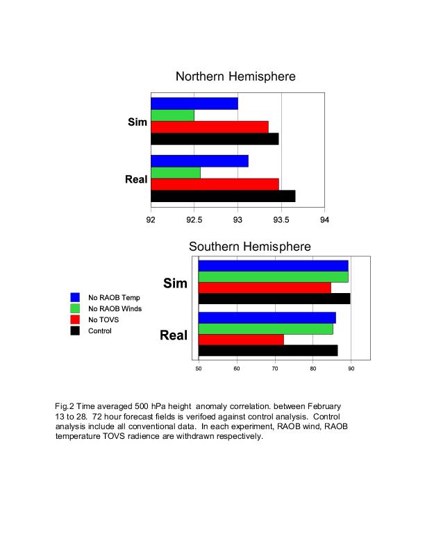
First , the impact was measured as geographical distribution of time averaged root mean square error (RMSE) between analysis and forecast fields. The results show generally satisfactory agreement between real and simulated impacts. In the Northern Hemisphere (NH), the impact of RAOB winds is slightly weaker in the simulation and the impact of RAOB temperature is slightly stronger in the simulation. Particularly in the tropics, there is a large impact from RAOB temperature in the analysis which does not increase with forecast hour. The impact of TOVS is slightly larger in the simulation. In NH, TOVS has little impact over Europe and Asia but shows an impact over the Pacific for both real and simulated analyses. The magnitudes are slightly larger in the simulation but the patterns are similar. In the 72 hour forecast, the impact of TOVS spreads out over the NH and shows a similar magnitude of impact compared to RAOB temperature. In the Southern Hemisphere (SH) TOVS dominates. However, with TOVS, RAOB data do exhibit some impact and their impacts are similar between the simulated and real analyses.
The larger impact of TOVS in the simulation is expected because of the lack of measurement error in the simulated data. Under-estimation of the cloud effect in the simulation is another possible reason for the large impact in the simulation. The large analysis impact in the tropics may be related to the bias between the NCEP model and the nature run. Inclusion of a bias correction in the data assimilation is being considered (Purser and Derber, 2001).
5.3. Impact on forecast Skill
Anomaly correlations for 500hPa height fields for 72 hour forecast skill for the experiments without TOVS (NTV), experiments without RAOB winds (1BNWIN), and experiments without RAOB temperature (1BNTMP) are presented in Fig. 2. The forecast skills are verified against experiments with all data (CTL). For both real and simulated experiments, 1BNWIN shows the least skill in the northern hemisphere (NH) and globally less skill compared to 1BNTMP. Therefore RAOB winds have more impact compared to RAOB temperatures in both simulated and real cases and the NH and SH.
The simulated TOVS data are supposed to be better quality than the real TOVS, because various systematic errors and correlated large scale errors have not been added to the simulation. Therefore, it is expected that denial of the simulated TOVS would result in more skill reduction than denial of the real TOVS. However, in SH, the impact of real TOVS is much larger than the simulation. This is due to the variable SST in real data and constant SST in simulation. These results indicate that if SST has large variability, the impact of TOVS become more important.
5.4 Adjustment of Error for the simulated data
The problems in the original simulated data are noted in 3.1. In order to improve the simulated data, simulations using real orography and the formation of systematic error have been conducted by NCEP.
Since NR is the model value it does not include smaller scale errors compared to NR resolution, which is about 50Km. The real data have small scale errors due to subgrid scale structures. This is particularly true for surface data. In the NR envelope orography is used. Missing observations between NR orography and real orography and lack of missing unrepresentative errors will cause larger weight of surface data. This will cause less space for future instruments to make an additional impact.
A new technique for simulating observations has been developed by the NCEP OSSE project and is now being tested. The observational-analysis difference (o-a) for each observation was computed from the real analysis at each observation time. These values were added to the errorless simulated data for that time. The o-a value from the real analysis includes representativeness errors that come from subgrid-scale structures. These representativeness errors were already removed from the NR data as it came from a model integration.
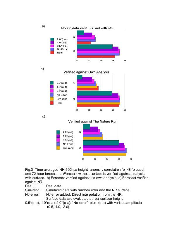
In order to test sensitivity to observational error, the difference between observation and analysis (o-a) from the real data assimilation is used as the error for the simulated data. This error will give a large-scale correlated error. The following sets of experiments are selected to test the forecast and detail comparisons. The impact of removing surface data, forecast skill against NR, and forecast skill against their own analysis are compared in Fig.3.
Real: Real data
Sim(random Err): Simulated data with random error and the NR surface
No-error: No error added. Direct interpolation from the NR.
Surface data are evaluated at real surface height
0.5*(o-a), 1.0*(o-a), 2.0*(o-a): "No-error" plus (o-a) with various amplitude (0.5, 1.0, 2.0)
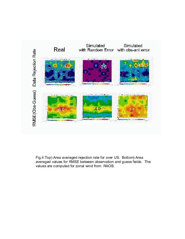
With (o-a) error, the rejection statistics of simulated experiments become closer to those for real data (Fig.4.) With random error, too little data are rejected by quality control. Adding random error to the surface data helped to make the surface data impact more realistic. The optimum coefficient for (o-a) is between 1.0 and 2.0 for the SH. The error in sim0 is slightly less than no-error. Random error could have smoothing effect to increase the skill artificially. This may be caused by too optimistic surface data in sim0. Further experiments to determine the cause this results are being conducted.
Further improvement on (o-a) will be conducted. For example iteration of the process is considered to achieve more realistic observational error.
5.5 Summary
The results show that simulations reproduced major features of the impact in the real data. Error assignment requires further investigation. CMV and AIRS need to be used for calibration to demonstrate impact on the future observing system. The data impact is also expected to change when new features are added to the data assimilation system.
6. ASSESSMENT OF DOPPLER WIND LIDAR (DWL) IMPACT
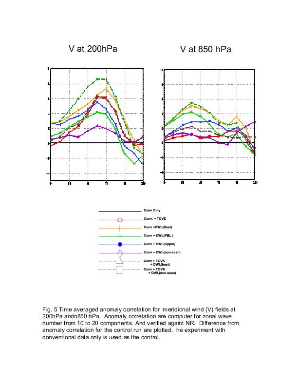
Many experiments have been tested to illustrate the impact of conventional and DWL data for the first several days. Then selected sets of experiments are extended to whole NR period, with forecasts also being performed. The impact of DWL is assessed by using anomaly correlation in various space scales and by a synoptic analysis of case studies. Time averaged geographical distribution and time series of a RMS error are also studied. Consensus among different measures of skill are examined for the assessment. (Fig.5)
The advantage of DWL scanning was clear. Particularly in NH, it is very difficult to expect a significant impact without scanning. However, compared to TOVS data, even the DWL-non-scan data show more impact than the 1993 level TOVS at almost all scales and variables.
At 850hPa, the skill of DWL-PBL was better than the DWL-upper analysis. However, after 48-72 hours the forecast with DWL-upper becomes better. This is observed for various values and at various latitudes. This indicates that upper level data are much more important than low level data beyond 48 hours.
In the NH, skill in the global scales is mostly achieved by existing (conventional and TOVS) data. Therefore, the impact of DWL at synoptic scales is most important. The skill for zonal wind (U) and temperature (T) are mainly from planetary scale events and the skill for meridional wind (V) is from the synoptic scale. Therefore, the impact of DWL is much clearer on V than U or T.
In the tropics, DWL shows a large positive impact in most configurations tested. Even the non-scan DWL has more impact than TOVS. The positive impact is reduced with forecast time; the large positive impact with the best DWL in the analysis decreases by half beyond the 72 hour forecast. With TOVS and DWL together, the impact is larger than TOVS alone but less than DWL alone.
6.1 Evaluation of the results
The sensitivity to the Representativeness error (r-DWL), which is an additional error based on the error used for wind data, has been tested. Ideally, r-DWL must be a function of various parameters such as the number of shots, height, and latitude. However, for the evaluation the effect of r-DWL is kept constant. The results showed that analysis with DWL become closest to NR, if r-DWL is between 1.0 and 2.0. If r-DWL is too small, the DWL data take analysis away from NR. Increasing r-DWL does not solve the problem of negative impact of TOVS over DWL. Representativeness error for TOVS, random error, and balance relation within data assimilation will be tested to investigate the cause of the negative impact of TOVS. This results will provide be valuable evaluation to real data assimilation.
7. PLANS FOR FUTURE WORK
In the next year, the OSSE project will concentrate on using simulated observations from the advanced sounders, AIRS and CrIS. AIRS data have already been simulated by Kleespies (NESDIS) and the simulation of CrIS data will begin in the coming months. In addition, more realistic DWL configurations will be tested. Sensitivities to the quality of simulated observations and the assumed data quality in the analysis will be investigated. Investigations into adaptive observing strategies may be supported (a proposal submitted to the NPOESS IPO). Some fundamental issues in the design of observing networks will be conducted to estimate the upper bound of forecast impact from various observing strategies.
The following work to be done by OSSE project at NCEP with collaboration with NESDIS, SWA and DAO.
A. The project has produced a large variety of sensitivity studies, including results demonstrating the impact of bias and representativeness errors on forecast quality. These studies will be documented with a comprehensive report.
B. The impact of systematic errors in both conventional and satellite radiance will be continued.
C. Testing of advanced sounder data, including NPP instruments, will begin. NESDIS is working on a simulation of the Cross track Infrared Sounder (CrIS) data. OSSEs will be performed for these instruments, and the impact relative to those of various prototype DWL configurations will be evaluated. Advanced Scatterometer, CMIS, and ATMS are also candidates for simulation and eventual testing beyond this year.
D. Forecast impact of simulated AIRS and other Aqua instrument (AMSU, HSB) observations will be tested.
E. Simulated Cloud Motion Vector data will be tested with DWL and AIRS data.
F. The impact of DWL will be reassessed as simulations of conventional data are improved and more observation distribution are simulated. The sensitivity to assumed observation error levels will be tested to increase understanding of how various observations are used in the analysis system.
G. More realistic planned DWL configurations, such as DWL for ESA's Atmospheric Dynamic Mission (ADM) and NASDA's Japanese Experiment Module/Coherent Doppler Lidar (JEM/CDL), will be tested for forecast impact.
H. Theoretical studies to estimate the reliability of the results will be done in with coordination with DAO.
I. The impact of data processing, such as superobbing, will be tested. The current simulated DWL involves area averaging. This is the most simple way to do the superobbing but the technique may results in valuable information.
J. OSSEs to help designing adaptive observation strategies.
REFERENCES
Atlas, R. 1997:Atmospheric observation and experiments to assess their usefulness in data assimilation. J. Meteor. Soc. Japan, 75,111-130.
Atlas, R. 2002:Observing System Forecast Experiments at the DAO. AMS Preprint volume for the Sixth Symposium on Integrated Observing Systems. 13-17 January 2002, Orlando, Floprida. 37-39.
Atlas, R and J. Terry 2002: Observing System Simulation Experiments at NASA. http://dao.gsfc.nasa.gov/DAO_people/terry
Baker, W.E., G.D. Emmitt, F. Robertson, R.M. Atlas, J.E. Molinari, D.A. Bowdle, J. Paegle, R.M. Hardesty, R.T. Menzies, T.N. Krishnamurti, R.A. Brown, M.J. Post, J.R. Anderson, A.C. Lorenc and J. McElroy, 1995: Lidar-measured winds from space: An essential component for weather and climate prediction. Bull. Amer. Meteor. Soc., 76, 869-888.
Becker, B. D., H. Roquet, and A. Stofflen 1996: A simulated future atmospheric observation database including ATOVS, ASCAT, and DWL. BAMS, 10, 2279-2294.
Derber, J. C. and W.-S. Wu, 1998: The use of TOVS cloud-cleared radiances in the NCEP SSI analysis system. Mon. Wea. Rev., 126, 2287 - 2299.
Emmitt, G. D., 1999: Expanded Rationale for the IPO/NOAA Bracketing OSSEs http://www.emc.ncep.noaa.gov/research/osse/swa/DWLexp.htm
Emmitt, G. D., 2000a: Systematic errors in simulated Doppler wind lidar observations. http://www.emc.ncep.noaa.gov/resarch/osse/swa/sys_errors.htm
Emmitt G.D., S. A. Wood, S. Greco and L. Wood 2000b: Bracketing DWL Coverage OSSEs. Simpson Weather Associates.
Goldberg, M. D. , L. McMillin, W. Wolf, L. Zhou, Y. Qu, and M. Divakarla, 2001: Operational radiance products from AIRS, AMS 11th Conference on Satellite Meteorology and Oceanography 15-18 October 2001, Madison, Wisconsin. 555-558.
Kleespies, T. J. and D. Crosby 2001: Correlated noise modeling for satellite radiance simulation. AMS preprint volume for the11th Conference on Satellite Meteorology and Oceanography, October 2001, Madison Wisconsin. 604-605.
Kleespies, T. J., H. Sun, W. Wolf, M. Goldberg, 2003: AQUA Radiance computations for the Observing systems simulation experiments for NPOESS. Proc. American Meteorological Society 12th Conference on Satellite, Long Beach, CA, 9-13 February 2003.
Lord, S. J., E. Kalnay, R. Daley, G. D. Emmitt, and R. Atlas 1997: Using OSSEs i.n the design of the future generation of integrated observing systems. Preprint volume, 1st Symposium on Integrated Observation Systems, Long Beach, CA, 2-7 February 1997.
Masutani, M. K. Campana, S. Lord, and S.-K. Yang 1999: Note on Cloud Cover of the ECMWF nature run used for OSSE/NPOESS project. NCEP Office Note No.427
Masutani M., J. C. Woollen, S. J. Lord, J. C. Derber, G. D. Emmitt, Thomas J. Kleespies, J. Terry, H. Sun, S. A. Wood, S. Greco, R. Atlas, M. Goldberg, J. Yoe, W. Baker, C. Velden, W. Wolf, S. Bloom, G. Brin, C. O'Handley, 2002a: Progresses and future plans for Observing System Simulation Experiments for NPOESS, AMS preprint volume for 15th Conference on Numerical Weather Prediction 12--16 August 2002 in San Antonio, TX. 53-56. 346-349.
Masutani, M., J. S. Woollen, S. J. Lord,J. C. Derber, G. D. Emmitt, S. A. Wood, S. Greco, R. Atlas, J. Terry, T. J. Kleespies, H. Sun 2002b: Impact assesment of a doppler wind lidar for NPESS/OSSE. AMS preprint volume for 15th Conference on Numerical Weather Prediction 12--16 August 2002 in San Antonio, TX.
McNally, A. P., J. C. Derber, W.-S. Wu and B.B. Katz, 2000: The use of TOVS level-1 radiances in the NCEP SSI analysis system. Quar.J.Roy. Metorol. Soc. , 129, 689-724.
NESDIS/Office of Research and Applications. Forecast Products Development Team 2002: High Density Winds Match Statistics http://orbit35i.nesdis.noaa.gov/goes/winds/html/tseries.html
O'Handley C., G.D. Emmitt and S. Greco 2001: Simulating Cloud Motion Vectors From Global Circulation Model Data For Use in OSSEs: A Preliminary, But Useful, Algorithm For Application to Current NASA/NOAA OSSE Projects. Simpson Weather Associates. http://www.swa.com/cloudtrack/cloudmotionwinds.htm
Parrish, D. F. and J. C. Derber, 1992: The National Meteorological Center's spectral statistical interpolation analysis system. Mon. Wea. Rev., 120, 1747 - 1763.
Purser, R. J. and J. C. Derber, 2001: Unified Treatment of measurement bias and correlation in variational analysis with consideration of the preconditioning problem. AMS Preprint volume for the 14th Conference on Numerical Weather prediction. July 2001, Fort Lauderdale, Florida. 467-470.
Purser, R. J. and D. F. Parrish, 2000: A Bayesian technique for estimating continuously varying statistical parameters of a variational assimilation. NCEP Office Note 429. (To appear in Meteor. Appl. Phys.)
Purser, R. J., D.F. Parrish and M. Masutani 2001:Meteorological observational data compression; an alternative to conventional "Super-Obbing". NCEP Office Note 430.
van Delst,P., J.Derber, T.Kleespies, L.McMillin, and J.Joiner 2000: NCEP Radiative Transfer Model, Proceedings of the 11th International ATOVS Study Conference, Budapest, Hungary 20-26 September 2000
van Delst,P., Y.Tahara, J.Derber, T.Kleespies, and L.McMillin 2002: NCEP Radiative Transfer Model Status, Proceedings of the 12th International ATOVS Study Conference, Lorne, Australia 27 February-6 March 2002
Velden, C. S., C. M. Hyden, S. J. Nieman, W. P. Menzel, S. Wangzong, and J. S. Goerss 1997: Upper-tropospheric winds derived from geostationary satellite water vapor observations. Bull. Amer. Meteor. Soc., 78, 173-195.
Wood, S. A., G. D. Emmitt., and S. Greco 2001: The challenges of assessing the future impact of space-based Doppler Wind Lidars while using today's global and regional atmospheric models. AMS preprint volume for the Fifth Symposium on Integrated observing Systems, 14-19 January 2001, Albuquerque, NM. 95-101.
The Investigators, collaborators and advisors for this project are:
Principal Investigator:
Dr. Stephen J. Lord, Director
Environmental Modeling Center
National Centers for Environmental Prediction
National Weather Service/NOAA
Co-Investigators:
Dr. Michiko Masutani /NOAA/NCEP/EMC RSIS
John S. Woollen /NOAA/NCEP/EMC SAIC
Dr. Thomas Kleespies /NOAA/NESDIS/ORA
Dr. George D. Emmitt/SWA
Weiyu Yang /NOAA/NCEP/EMC SAIC
Dr. Russ Treadon NOAA/NCEP/EMC
Dr. Haibing Sun /NOAA/NESDIS/ORA QSS
Sid Wood SWA
Steve Greco SWA
Chris O'Handley SWA
Bert Katz /NOAA/NCEP/EMC SAIC
Joseph Terry /NASA/GSFC/GLA/DAO SAIC
Walter Wolf /NOAA/NESDIS/ORA QSS
Dr. John Derber /NOAA/NCEP/EMC
Dr. Christopher S. Velden /NOAA/NESDIS/ORA
Dr. Steve Bloom /NASA/GSFC/GLA/DAO SAIC
Dr. Genia Brin /NASA/GSFC/GLA/DAO SAIC
Dr. Robert Atlas /NASA/GSFC/GLA/DAO
Mitchell Goldberg/NOAA/NESDIS/ORA
Robert Kistler /NOAA/NCEP/EMC
Advised by:
Dr. Wayman Baker /NOAA/NCEP/NCO
Dr. Eugenia Kalnay University of Maryland
Dr. James Yoe /NOAA/NESDIS/ORA
The panel members are:
Don Norquist AFGL (Dept. of Defense) (Chair)
Dr. Akira Kasahara NCAR
Prof. T. N. Krishnamurti Florida State Univ.
Prof. Jan Paegle Univ. of Utah
Dr. Ed Eloranta (University of Wisconsin)
Jeff McQueen (NWS)