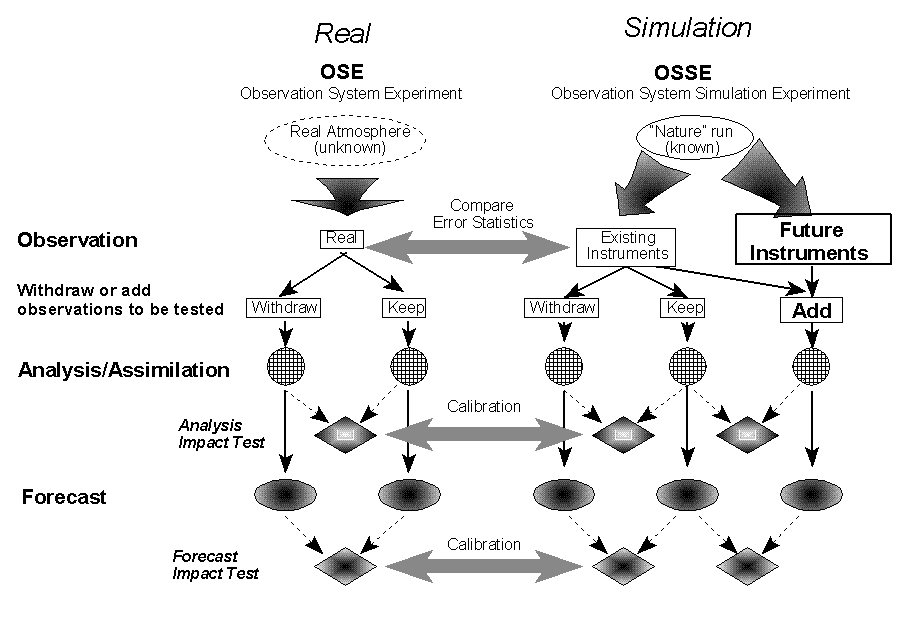
Fig.1 Principal components of Observing System Simulation Experiments and their relationship with real Observation Sensitivity Experiments.
5.9
Observing System Simulation Experiments for NPOESS
Stephen J. Lord, Michiko Masutani*, John S. Woollen, John C. Derber
NOAA/NWS/NCEP/EMC, Camp Springs, MD
Robert Atlas, Joseph Terry
NASA/GSFC/DAO, Greenbelt, MD
G. David Emmitt, Sidney A. Wood, Steven Greco
Simpson Weather Associates, Charlottesville, VA
Thomas J. Kleespies, Vaishali Kapoor
NOAA/NESDIS, Camp Springs, MD
http://www.emc.ncep.noaa.gov/research/osse
1. INTRODUCTION
Global atmospheric observing systems, such as those on NOAA's current Polar-orbiting Operational Environmental Satellites (POES), provide data for Numerical Weather Prediction (NWP) forecasts and the means to monitor and assess the climate. The future National POES System (NPOESS) is scheduled to fly during the 2007-2010 period. For the next 10 years, a considerable amount of effort must take place to define, develop and build the suite of instruments which will comprise the NPOESS. The forecast impact of current instruments can be assessed by Observing System Experiments (OSEs), in which already existing observations are denied or added to observations from a standard data base. However, the impact of future instruments must be assessed with experiments using simulated observations. These experiments are known as Observing System Simulation Experiments (OSSEs).
This project is a collaboration among several organizations. Data assimilation will be performed mainly by a technology-neutral organization, the National Centers for Environmental Prediction (NCEP), with collaboration with the NASA/Data Assimilation Office (DAO) and the Naval Research Laboratory (NRL). From the instrument community, Simpson Weather Associates (SWA) and NOAA scientists are participating in the simulation of Doppler Wind Lidar (DWL) observations, and the National Environmental Satellite, Data and Information Service (NESDIS) will simulate both existing and future thermodynamic sounders. NASA/DAO will simulate conventional observations.
Through this collaboration, the data assimilation and modeling communities will be involved in instrument design and can provide information about the expected impact of the new instruments. Furthermore, through the OSSEs, operational data assimilation systems will be ready to handle new data in time for the launch. This process involves the evaluation of the operational load, the development of the data base and data-processing, and a quality control system. All of this development will accelerate the operational use of data from the future instruments (Lord et al. 1997).
For the OSSE, a long integration of an atmospheric general circulation model (GCM) is required to provide a "true atmosphere" for the experiment. This is called the "nature run". The nature run needs to be sufficiently representative of the actual atmosphere and but different from the model used for the data assimilation. For this project, the nature run was provided by the European Centre for Medium-Range Weather Forecasts (ECMWF). The representativeness of the nature run was evaluated and found to be suitable to conduct OSSEs.
Fig.1 shows the diagram of OSSEs and OSEs. In the calibration process, the results from data impact tests for existing instruments from OSSEs need to be compared with the results from OSEs. The calibration process provides guidelines to evaluate the impact of the future instruments based on their OSSE. The relative importance of wind and mass data for analysis and forecast accuracy will be elucidated through the calibration.
From the possible future instruments,
simulated DWL wind has been tested by the
OSSEs. The bracketing OSSE has been proposed
to conduct technology-neutral experiments for DWL
wind (Emmitt 1999).
2. EVALUATION OF THE NATURE RUN
A forecast model run for one month duration, made by the ECMWF at resolution T213 and 31 levels starting from 5 February 1993, is chosen as the first nature run to simulate the atmosphere (Becker et al 1996). The data were provided as either T213 spectral coefficients and reduced Gaussian grid at a resolution of approximately 60 km at 31 model levels. The gridded data were expanded to regular gaussian grid and saved in GRIB format for use in the OSSE. The version of the model used for the nature run is the same as in the ECMWF reanalysis, containing Tiedtke's mass flux convection scheme (Tiedtke 1989) and prognostic cloud scheme (Tiedtke 1993).
The nature run was found to be
representative of the actual atmosphere in many
ways (Masutani et al. 1999a,1999b). But there is
excessive low level cloud over land and a lack of
low level cloud over ocean. The low level cloud was
adjusted by adding stratus and stratocumulus based
upon rising motion in the nature run and
climatological values based on ground-based
observations (Masutani, et al. 1999b, 1999c).
3. SIMULATION OF OBSERVED DATA
3.1 Simulation of Conventional Observations
Simulation, of realistic conventional observations and satellite observations consisting of cloud motion wind vectors is conducted by Atlas and Terry (2000). Information from a real observational database is used to obtain the necessary spatial and temporal distribution to produce a representative sampling for the simulated observational database. The initial simulation experiment uses a subset of the same real observational data set used by the NCEP 40-year reanalysis project. However, cloud track winds based on the nature run wind will also be tested.
The gridded nature data are interpolated bilinearly to the latitude and longitude coordinates of each report. For observations lying on non-mandatory levels, a linear in log pressure interpolation is performed between the closest two vertical levels and the observational level. A simple linear interpolation in time is also performed between the two bracketing six hour nature times to the time of the observation.
For land surface observations, all measured quantities are simulated from nature surface fields including surface pressure. The same is true for ocean surface observations, except the nature sea level pressure field is used to simulate station pressure. Real observations which are available above the nature atmosphere above 10 mb, are not simulated. Given the data assimilation system that is being used for the NPOESS OSSE's, this should not impact the OSSE results.
Uncorrelated random noise is added to perfect simulated observations using a Gaussian normal distribution of numbers along with observational error standard deviations. A set of random Gaussian normal values are generated for each report with the characteristics of having a mean of zero and a standard deviation of one. The observational error standard deviations (Stoffelen et al., 1994) are obtained from tables produced at ECMWF for each observing system, mandatory pressure level and atmospheric quantity that is directly measured. For rawinsondes, an additional error of 10% is applied to significant level observations.Due to the improved accuracy of observations from ACARS over those obtained from conventional aircraft, conventional aircraft observation errors would be too pessimistic if applied to ACARS. Instead, rawinsonde errors are used since rawinsondes appear to resemble ACARS more closely than any other observing system with respect to the magnitude of the observational error (Schwartz and Benjamin, 1995). In addition to the Gaussian error, an attempt is made to simulate the error incurred by the downstream drift of a rawinsonde balloon from its launch site.
Wind error standard deviations are directly
available in component form only. However, it is
more consistent to apply errors to wind observations
in the form of a direction and speed rather than as
u and v components since wind direction and speed
are the characteristics of the wind field that are
measured directly by conventional instruments. To
achieve this, a wind direction and speed error
standard deviation is derived analytically using the
relationship between the direction and speed and
the u and v components.
3.2 Simulation of TOVS radiance data
HIRS radiances have been simulated by NOAA/NESDIS. The basic radiative transfer code is RTTOV version 5 (Saunders et al., 1998). This code can produce both clear and cloudy radiances, and permits user specified emissivities. This code is used because it has different design philosophy and uses different spectroscopy than the operational NCEP model, which is based upon OPTRAN (McMillin et al., 1995). This is important to avoid over optimistic results in the OSSEs due to so called the "identical twin" problem.
The level 1B files were processed one record at a time, with the three calibration records in each superswath copied to the output file. Each record contains information for one scan line, which is 56 observations of 20 channels (19 infrared and one visible). The visible data for each spot were copied to the output record. For each spot the latitude and longitude were extracted. The nature run temperature, mixing ratio, pressure profile, cloud amount, surface wind speed and surface skin temperature were interpolated to the spot location. The historical ozone data were provided by Mel Gelman of NCEP/CPC, and these were also interpolated to the spot location.
The RTTOV code does not permit multiple cloud layers, so the following logic was used to simulate clouds. A maximum of two cloud layers was permitted. The possible options are: clear, completely cloudy with one layer, partly cloudy with one or two cloud layers. Maximum overlap was assumed for the case of two cloud layers. First the nature run cloud profile was scanned to determine if the spot was completely cloudy, which is defined here as a cloud fraction greater than 0.8 . Otherwise, the cloud profile was scanned to see if the spot was clear, which is defined as a cloud fraction of less than 0.2 . If these two tests fail, then a search is made for the two topmost local maxima in cloud amounts. Since RTTOV returns both clear and cloudy radiances, a maximum of two calls is required to satisfy these conditions. The cloudy and clear radiances were then combined using a sum weighted by the relative cloud amounts.
The surface emissivity was determined using a scheme from Masuda et al. (1988). This method gives ocean IR emissivity as a function of wind speed and zenith angle. The land emissivity was set to 0.98.
Instrument noise was characterized by collecting statistics from space calibration data for one day in the middle of the nature run. Correlated Gaussian noise was generated by the method of Searle (1988), and added to the computed radiances. Finally the radiances were converted to instrument counts using the 1B calibration coefficients that correspond to that scan line.
The methodology for simulating MSU
observations is identical to that of the HIRS, with
the exception of surface emissivity. Here the
microwave surface emissivity model that is
included with RTTOV is used (English and Hewison,
1998).
3.3 DWL Data Simulation
The first simulated DWL wind data are produced as the line-of -sight (LOS) wind by SWA using their Lidar Simulation Model (LSM). Space-based application of DWL technology is without heritage. Thus, optimal design of DWL systems for space deployment must rely upon simulation experiments. The simulation of DWL data include efforts with DWL performance models, atmospheric circulation models and atmospheric optical models (Atlas and Emmitt, 1995; Emmitt, 1995a; Emmitt and Wood, 1996; Wood et al., 1993; Wood et al., 1995).
The steps between a notional concept for a DWL and the blueprints for instrument construction include a considerable amount of performance modeling and, for space-based systems, an intensive series of OSSEs. During and subsequent to the Laser Atmospheric Wind Sounder (LAWS) study (Baker et al., 1995), a method for assessing the potential impact of a new DWL observing system was established. The instrument parameters are provided by the engineering community. Scanning and sampling requirements are provided by the science community and define various instrument scenarios. These scenarios are tested initially by examining the sensitivity of analyses to the various scenarios. A candidate DWL concept is then chosen for a full OSSE, and an impact study is then conducted and evaluated by a technology-neutral group.
The bracketing OSSEs are being performed
for various DWL concepts to bound the potential
impact. Later OSSEs will be performed for more
specific instruments (Emmitt, 1999). The following
"technology-neutral" observation coverage and
measurement error characterizations will be
explored.
EXP 1(Best): Ultimate DWL that provides full
tropospheric LOS soundings, clouds permitting.
EXP 2 (PBL+cloud): An instrument that provides only wind observations from clouds and the PBL.
EXP 3 (Upper): An instrument that provides mid
and upper tropospheric winds only down to the
levels of significant cloud coverage.
Exp 4 (Non-Scan): A non-scanning instrument that provides full tropospheric LOS soundings, clouds permitting, along a single line that parallels the ground track.
Reference: Perfect u,v observations from an
orbiting instrument at single points within the
targeted resolution volume (TRV). No cloud or sub-grid wind variability effects accounted for.
TRV : 200kmx200kmxT
T: Thickness of the TRV
0.25 km if z<2km, 1km if z>2km
0.25 km for cloud return
Swath width: 2000 km except for EXP4 (non-scanning)
No measurement error is assigned for the
initial test. Strategies for systematic errors are
discussed by Emmitt (2000). Data products based
upon clustered and distributed shots are generated
for each experiment except for the reference
experiment. The clustered data product is based
upon averaging the observations associated with
shots clustered within an area that is very small
compared to the base area of the TRV. The
distributed data product is based upon averaging the
observations of shots distributed throughout the
TRV as would result from continuous conical
scanning
4. DATA ASSIMILATION SYSTEM AND IMPACT
TEST
The data assimilation system at NCEP is based on the "Spectral Statistical Interpolation (SSI)" of Parrish and Derber (1992), which is a three-dimensional variational analysis (3-D var.) Scheme. In 1995, the assimilation system was modified to use TOVS cloud-cleared radiances instead of using temperature and moisture vertical retrievals, and significant improvements were reported by Derber and Wu (1998). In January 1998, the use of pre-processed radiance data (traditionally referred to as level-1b data) became operational (McNally et al., 1998, 2000) and an upgrade to this system was implemented in June 1998. The March 1999 version of NCEP's operational Medium Range Forecast (MRF) and data assimilation system is used for the current data impact test. Line of sight (LOS) winds from DWL are directly used in the data assimilation.
Impact tests for TOVS level-1b radiance, RAOB temperature, and RAOB wind will be conducted for the nature run period. The experiments will utilize the NCEP operational data assimilation system March 99 version with T62 horizontal resolution and 28 vertical levels. The tests will be repeated with simulated data. In order to perform reliable OSSEs for future instruments, the impact of existing instruments in both real and simulated experiments are used for calibration.
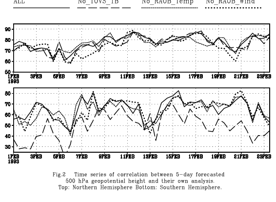
Data assimilation with real data was
performed from 1 Jan 1993 to 31 March 1993. Fig.
2 shows the time series of the correlation between
analysis and the day-5 forecast for following
experiments for February 1993. They are evaluated
against their own analysis. Table 1 shows the time
averaged correlation.
Control (ALL):
Include TOVS 1B radiance and all RAOB and other
conventional data
No TOVS 1B (NTV):
Withdraw TOVS data from control
No RAOB Wind:
Withdraw RAOB wind from control
No RAOB Temp:
Withdraw RAOB temperature from control
TOVS radiance has the largest impact in the Southern Hemisphere. RAOB wind has the highest impact on the Northern Hemisphere. However, this diagram also shows that the data impact has a large spread and depends on events.
5. SOME INITIAL RESULTS FROM OSSE
For OSSE experiments, data assimilation with conventional data only (sim.NTV) is started from 06Z 5 February, the first period of the nature run. The initial condition was obtained from NTV, corresponding to the experiment for the real data. The difference between NTV and sim.NTV increases with time for several days. Other data are added or subtracted after the distance between NTV and sim.NTV has stabilised. The results are still under evaluation. Some initial observations indicate that OSSEs tend to show higher impact over the Nothern Hemisphere compared to OSE.
OSSEs with DWL wind data show increased
impact with scanning and with area averaging. The
vertical distribution of impact among "Best",
"PBL+Cloud", "Upper" are reasonable. These
results show that the data are simulated and
analyzed correctly. However, in order to provide
useful information for NPOESS, further careful
calibration is required.
6. CONCLUDING REMARK
In addition to a DWL, the atmospheric infrared sounder (AIRS), the Cross track Infrared Sounder (CrIS), Conically scanning Microwave Imager/Sounder (CMIS), and the Advanced Technology Microwave Sounder (ATMS) have been proposed as candidate instruments to be tested by OSSEs. We are proceeding to develop appropriate forward models for these instruments.
The seasonal dependence of the data
impact is suggested. An alternative nature runs to
test summer time response could be important.
Ideally the nature runs from other models should
also be considered to confirm the results.
ACKNOWLEDGMENT
We received much assistance from Keith Fielding, John Hennessy and John Chambers of the Data Services Section of ECMWF. Informal discussion with Dr. Christian Jakob of ECMWF was crucial for evaluating the nature-run clouds. Drs. Roger Saunders and Anthony Hollingsworth of ECMWF provided generous support towards this project. We would like to thank Drs. Larry Stowe and Andrew Heidinger for providing CLAVR data. Throughout this project NCEP staffs provide numerous technical assistance and advice. Particularly, we thank Russ Treadon, Weiyu Yang, Kenneth Campana, W.-S. Wu, R. Kistler, Y. Zhu, W. Collins, Mark Iredel, S.-K. Yang, B. Katz, Song-You Hong, and D. Keyser. Technical assistance was also provided by Dr. N. Wolfson of NASA/DAO. Drs. E. Kalnay, W. Baker, J. Yoe and R. Daley provided expert advice. We also received valuable advice from Drs. Genia Brin, Dick Dee, and Stephen Bloom of NASA/DAO. We appreciate the constructive comments from members of the OSSE Review Panel.
This project is sponsored by the Integrated
Program Office (IPO) for NPOESS, and we would
like to thank Dr. Stephen Mango for his support.
This project is also supported by NOAA/Office of
Atmospheric Research (OAR)NOAA/National
Environmental Satellite, Data and Information
Service (NESDIS) and we would like to thank Dr.
Jim Ellickson for his support.
REFERENCES
Atlas, R. and G.D. Emmitt, 1995: Simulation studies of the impact of space-based wind profiles on global climate studies. Proc. AMS Sixth Symp. on Global Change Studies, Dallas, TX, January.
Atlas, R. and J. Terry, 2000:Simulation of Conventional and Cloud Motion Wind Observations,
http://dao.gsfc.nasa.gov/DAO_people/
terry/npoess.html
Becker, B. D., H. Roquet, and A. Stofflen 1996: A simulated future atmospheric observation database including ATOVS, ASCAT, and DWL. BAMS, 10, 2279-2294.
Baker, W.E., G.D. Emmitt, F. Robertson, R.M. Atlas, J.E. Molinari, D.A. Bowdle, J. Paegle, R.M. Hardesty, R.T. Menzies, T.N. Krishnamurti, R.A. Brown, M.J. Post, J.R. Anderson, A.C. Lorenc and J. McElroy. ,1995: Lidar-measured winds from space: An essential component for weather and climate prediction. Bull. Amer. Meteor. Soc., 76, 869-888.
Derber, J. C. and W.-S. Wu, 1998: The use of TOVS cloud-cleared radiances in the NCEP SSI analysis system. Mon. Wea. Rev., 126, 2287 - 2299.
Emmitt, G.D., 1995: OSSE's in support of a small-satellite mission. Paper presented at the NOAA Working Group on Space-based Lidar Winds, Clearwater, FL, January 31-February 2.
Emmitt, G. D., 1999: Expanded Rationale for the IPO/NOAA Bracketing OSSEs http://www.emc.nceo.noaa.gov/resarch/osse/swa/DWLexp.htm
Emmitt, G. D., 2000: Systematic errors in simulated Doppler wind lidar observations.
http://www.emc.nceo.noaa.gov/
resarch/osse/swa/sys_errors.html
Emmitt, G.D. and S.A. Wood. Lidar Mapping of Cloud Tops and Cloud Top Winds, 1996. PL-TR-96-2129, F19628-93-C-0196, 1996
English S. and Hewison T.J. 1998 A fast generic millimetre-wave emissivity model. SPIE proc.Kidwell, K. The Polar Orbiter Users Guide,
http://www2.ncdc.noaa.gov:80/docs/podug
Lord, S. J., E. Kalnay, R. Daley, G. D. Emmitt, and R. Atlas 1997: Using OSSEs in the design of the future generation of integrated observing systems. Preprint volume, 1st Symposium on Integrated Observation Systems, Long Beach, CA, 2-7 February 1997.
Masuda, K., T. Takashima, and Y. Takayama, 1988: Emissivity of pure and sea waters for the model sea surface in the infrared window regions. Remote Sens. Env. 24:313-329.
Masutani,M, K. Campana, and S.J..Lord 1999a:AMS Preprint volume for the 3rd Symposium on Integrated Observing Systems. 10-15 January 1999, Dallas, TX, 28-31.
Masutani, M., J.C. Woollen, J.C. Derber, S. J. Lord, J. Terry, R. Atlas, S. A. Wood, S. Greco, G. D. Emmitt, T. J. Kleespies 1999b: "Observing System Simulation Experiments for NPOESS", AMS reprint volume for the 13th conference on Numerical Weather prediction. September 1999, Denver Colorado,1-6.
Masutani, M. K. Campana, S. Lord, and S.-K. Yang 1999c: Note on Cloud Cover of the ECMWF Nature run used for OSSE/NPOESS project. NCEP Office note No.427
McMillin, L. M., L. Crone and T. J. Kleespies, 1995: Atmospheric transmittance of an absorbing gas. 5: Improvements to the OPTRAN approach. Appl. Opt. 34 (36) 1995.
McNally, A. P., J.C. Derber, W.-S. Wu and B.B. Katz, 1998: The use of TOVS level-1B radiances in the NCEP SSI analysis system. Technical Procedure Bulletin 445, National Weather Service, Office of Meteorology.
Parrish, D. F. and J. C. Derber, 1992: The National Meteorological Center's spectral statistical interpolation analysis system. Mon. Wea. Rev., 120, 1747 - 1763.
Saunders, R.W., Matricardi M and Brunel P, 1998: An improved radiative transfer model for assimilation of satellite radiances QJRMS 124.
Searle, 1982: Matrix Algebra Useful for Statistics, Wiley&Sons, Ch 13.
Tiedtke, M. 1989: A comprehensive mass flux scheme for cumulus parametrization in large scale model. Mon. Wea. Rev., 117, 1779-1800.
Tiedtke, M. 1993: Representation of clouds in large-scale models. Mon. Wea. Rev. 121, 3040-3061.
Wood, S. A., G.D. Emmitt, M. Morris, L. Wood and D. Bai. Space-based Doppler lidar sampling strategies -- algorithm development and simulated observation experiments. Final Rept. NASA Contract NAS8-38559, Marshall Space Flight Center, 266 pp., 1993.
Wood, S. A., G.D. Emmitt, D. Bai, L.S. Wood, and S. Greco, 1995: A coherent lidar simulation model for simulating space-based and aircraft-based lidar winds. Paper presented at the Optical Society of America's Coherent Laser Radar Topical Meeting, Keystone, CO, July 23-27.
Wood, S. A., G. D. Emmitt and S. Greco, 2000;DLSM: A Coherent and Direct Detection Lidar Simulation Model for Simulating Space-based and Aircraft-Based Lidar Winds. Proceedings SPIE's 14th Annual Intern. Symp. Aerospace Sensing, Simulation and Controls, Orlando Fl, April.
Wood, S. A., G. D. Emmitt and S. Greco, 2000; The
Challenges of Assessing the Future Impact
of Space-based Doppler Wind Lidars while
Using Today's Global and Regional
Atmospheric Models. Poster to be
presented at the AMS's Fifth Symposium on
Integrated Observing Systems,
Albuquerque, New Mexico.
* Corresponding Authors address: Michiko Masutani, NOAA/NWS/NCEP/EMC, 5200 Auth Road Rm 207, Camp Springs, MD 20746; email:michiko.masutani@noaa.gov
| NH | SH | |
| All | 77.7 | 65.4 |
| No TOVS 1B | 76.6 | 49.3 |
| No RAOB Temperature | 77.4 | 64.9 |
| No RAOB Wind | 75.3 | 64.6 |
Table 1. Time mean values of the correlation in Fig.2.
Fig.1 Principal components of Observing System Simulation Experiments and their relationship with real Observation Sensitivity Experiments.