THE OBSERVING SYSTEM SIMULATION
EXPERIMENTS FOR NPOESS
Michiko Masutani, Kenneth Campana,
and Stephen J. Lord
EMC/NCEP/NWS/NOAA
1.NTRODUCTION
Global atmospheric observing systems, such as those on Polar-orbiting Operational Environmental Satellites (POES), provide the basic data for Numerical Weather Prediction (NWP) forecasts and the means to monitor and assess climate. The National POES System (NPOESS) is scheduled to fly in the 2007-2010 time frame. For the next 10 years, a considerable amount of effort must take place to define, develop and build the suite of instruments which will comprise the NPOESS. While forecast impact of current instruments can be assessed by Observing System Experiments, in which already existing observations are denied or added to observations from a standard data base, the impact of future instruments must be assessed with experiments using simulated observations. These experiments are known as Observing System Simulation Experiments (OSSEs).
This project is a collaboration among several organizations. Data assimilation will be tested by three different systems at the National Centers for Environmental Prediction (NCEP), NASA/data assimilation office (DAO) and the Naval Research Laboratory (NRL). From the instrument community, Simpson Weather Associates (SWA) and others are participating to simulate Dopplar Wind Lidar (DWL) observations, and the National Environmental Satellite, Data and Information Service (NESDIS) will simulate both existing and future thermodynamic sounders. Through this collaboration, data assimilation and modeling communities will be involved in instrument design and can provide information about the expected impact of the new instruments. Furthermore, through the OSSEs, operational data assimilation systems will be ready to handle new data in time for the launch. This process involves the evaluation of operational load, the development of the data base and data-processing, and a quality control system. All of this development will accelerate the operational use of data from the future instruments. (Lord et al. 1997)
For the OSSE, a long integration of an atmospheric general circulation model (GCM) is required to provide a "true atmosphere" for the experiment. This is called the "nature run". The nature run needs to be sufficiently representative of the actual atmosphere and also exhibit differences from the model used for the data assimilation. For this project, the nature run is provided by the European Centre for Medium-Range Weather Forecasts (ECMWF).
In this paper the work performed at NCEP is presented. The nature run chosen for this
project is evaluated. The impact of existing data is tested to demonstrate the performance of
NCEP's data assimilation system. The work performed by other institutes are referenced and
presented in the OSSE web site at "http://nic.fb4.noaa.gov:8000/research/osse".
2. EVALUATION OF THE NATURE RUN
A forecast model run for one month duration, made by the ECMWF at resolution T213 and 31 levels starting from 5 February 1993, is chosen as the first nature run to simulate the atmosphere (Becker et al 1996). The data were provided as either T213 spectral coefficients or reduced gaussian grid data at resolution of approximately 60km. The gridded data were expanded to a 640×320 regular gaussian grid and saved in GRIB format for use in the OSSE.
In general, February 1993 was typical for the Northern Hemisphere winter. The El Niño/Southern Oscillaion condition during February 1993 was close to normal and there was no significant tropical sea surface temperature anomaly. A well organized tropical intraseasonal oscillation (TIO) was active between November 1992 to mid- February 1993 but disorganized thereafter. The dominant midlatitude pattern during February 1993 was an Eastern North Atlantic pattern (Climate Diagnostics Bulletin, Climate Prediction Center/NCEP).
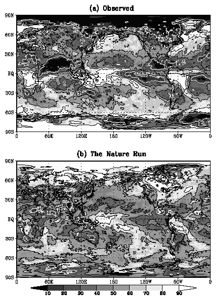
In order to produce realistic DWL data sampling, the nature run cloud distribution should be realistic. A detailed assessment of the nature run clouds is given by M. Masutani, K. Campana and S.-K. Yang of NCEP and S. Wood and D. Emmitts of SWA, and is on display at the OSSE/NPOESS website. Fig. 1a is the total cloud cover estimated by Real-Time Nephanalyses (RTN, Hamill 1992, Henderson-Sellers 1986). Fig. 1b shows the total cloud cover from the nature run averaged between 5 February and 6 March. The cloud parameterization by Tietke (1993) was used for the nature run. The large differences over the north and south polar region were difficult to evaluate, due to the difficulties of estimating clouds from satellite over ice. In all likelihood, the nature run cloud may be closer to reality than the RTN estimate and other satellite estimates in polar regions (R. Grumbine, personal communication). The nature run high level cloud amount are much larger than the RTN data and seem more realistic, as NCEP's archive of RTN cloud data is known to underestimate the high level cloud. Marine stratocumulus is underestimated especially in mid-latitude, in this version of the ECMWF MRF model (C.Jakob personal communication) and some correction may be necessary. There is also an overestimation of low level-cloud over snow in the nature run (C.Jakob personal communication) . In the tropics, the lack of proper cloud patterns over Brazil and off the east African coast are noted. There is noticeable difference in the cloud vertical distribution in tropical convective regions. Considering the observational uncertainty in cloud estimation, and desiring to maintain consistency within the model, we find that clouds in the nature run are acceptable for this project.
The cyclone activities in the nature run and in the ECMWF reanalysis are compared by R.
Atlas and J.Terry of NASA/DAO (OSSE/NPOESS website). Remarkably similar cyclone tracks
and activity are reported.
3. DATA IMPACT STUDY USING NCEP DATA ASSIMILATION
SYSTEM
The data assimilation system at NCEP is based on the "Spectral Statistical Interpolation (SSI)" of Parrish and Derber, 1991, which is a three-dimensional variational analysis (3-D var.) Scheme. In 1996, the assimilation system was modified to use TOVS cloud-cleared radiances instead of using temperature and moisture vertical retrievals, and significant improvements were reported by Derber and Wu (1998). In January 1998, the use of pre-processed radiance data (traditionally referred to as level-1b data) became operational (McNally et al., 1998) and an upgrade to this system was implemented in June 1998.
In this study the impact of TOVS radiance is tested for February 1993, using the 1997 version of NCEP's operational Medium Range Forecast (MRF) model with T62 horizontal resolution and 28 vertical levels. Cloud-cleared TOVS data are obtained from the NESDIS data archive. The data assimilation without TOVS (NTV), and with TOVS cloud-cleared radiance data (TVR) are compared during February 1993. From each analyses, a five day forecast run was performed to evaluate the impact on forecast skill.
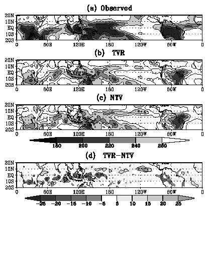
Tropical comparison of observed out-going long-wave radiation (OLR) (Fig.2a) show the OLR of TVR (Fig.2b) to be much closer to the observations than the OLR from NTV (Fig.2c). The peak around (100E, 10S) in NTV, which does not exist in the observations, is not evident in TVR (Fig.2d). In the eastern Pacific ITCZ, a narrow peak spread in east-west direction is produced in NTV(Fig.2c) but is significantly weakened in TVR (Fig.2d ) and becomes closer to observations. These improvements in data assimilation do not necessarily increase conventional forecast skill. After five days the TVR forecasted atmosphere becomes quite close to the NTV forecasted atmosphere.
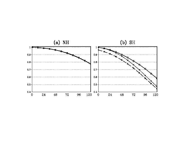
TOVS radiance data caused a significant improvement in the southern hemisphere
forecast. For the five day forecast, correlation to the analysis fields increases by 0.1 in TVR(0.6)
relative to NTV(0.5) (Fig. 3).
However, improvement in northern hemisphere is not clear, owing
to the comparatively large amount of conventional observational data. After five days, the
influence from the tropics becomes significant. Therefore, the tropical-extratropical interaction
in the GCM must be realistic enough to reproduce this process. This evaluation needs to be
developed through the OSSE in order to identify the true data impact.
4. SIMULATED DATA
TOVS data are being simulated by T. Kleespies at NESDIS. DWL data are being formatted for acceptance by NCEP SSI analysus and SSI is being modified to use Line of Sight (LOS) winds by J. Derber and J. Woolen. Conventional data and GOES winds are being simulated by J. Terry at NASA/DAO. Simulated DWL data will be produced for preliminary testing in the near future.
ACKNOWLEDGMENT
We received much assistance from Keith Fielding, John Hennessy and John Chambers of
Data
Services Section of ECMWF. Informal discussion with Dr. Christian Jakob of ECMWF was
crucial for evaluating the nature-run clouds. Drs. Roger Saunders and Anthony Hollingsworth
of ECMWF provided generous support towards this project. We thank J. Derber, J. Woolen,
S.-K. Yang, B. Katz, R. Kistler, W.-S. Wu, Y. Zhu, W. Collins and D. Keyser of NCEP, G. D.
Emmitt, S. Wood, S. Greco of SWA and R. Atlas and J. Terry, G. Brin of NASA/DAO and T.
Kleespies of NESDIS. Drs. E. Kalnay, W. Baker, and R. Daley provided expert advice. We
appreciate constructive comments from members of the OSSE review panel. This project is
sponsored by the Integrated Program Office (IPO) for NPOESS, and we would like to thank Dr.
Steven Mango for his support.
This paper is presented at the 3rd Symposium on Integrated Observing Systems. 10-15 January 1999, Dallas, TX
Corresponding author: Michiko Masutani, NCEP 5200 Auth Rd., Rm 807,
Camp Springs,
MD 20746. E-mail michiko.masutani@noaa.gov. Also affiliated with Research and Data
Systems Coorporation.
REFERENCES
Becker, B. D., H. Roquet, and A. Stofflen 1996: A simulated future atmospheric
observation
database including ATOVS, ASCAT, and DWL. BMAS, 10,
2279-2294.
Derber, J. C. and W.-S. Wu, 1998: The use of TOVS cloud-cleared radiances in
the NCEP SSI
analysis system. Mon. Wea. Rev., 126, 2287 - 2299.
Hamill, T. M., R. P. d'Entrement, and J. T. Bunting, 1992: A description of the
Air Force real-time, nephanalysis model, Weather and Forecasting,
7, 288-306.
Henderson-Sellers, A. 1986: Layer cloud amount for January and July 1979 from
3D-Nephanalysis, J. Climate Appl. Meteor., 24, 118-132.
Lord, S. J., E. Kalnay, R. Daley, G. D. Emmitt, and R. Atlas 1997: Using OSSEs
in the design of
the future generation of integrated observing systems. Preprint volume, 1st Symposium
on Integrated Observation Systems, Long Beach, CA, 2-7 February 1997. Posted at the
OSSE/NPOESS website.
McNally, A. P., J.C. Derber, W.-S. Wu and B.B. Katz, 1998: The use of TOVS
level-1B
radiances in the NCEP SSI analysis system. Technical Procedure Bulletin 445, National
Weather Service, Office of Meteorology.
Parrish, D. F. and J. C. Derber, 1992: The National Meteorological Center's
spectral statistical
interpolation analysis system. Mon. Wea. Rev., 120, 1747 - 1763.
Tiedtke, M. 1993: Representation of clouds in large-scale models. Mon.
Wea. Rev. 121, 3040-3061.
FIGURES
Fig. 1 (a) Observed total cloud cover estimated by RTN, averaged for February 1993. (b) Total cloud cover for the Nature run averaged from
5 February 1993 to 6 March 1993. Contour intervals are 20%. White contours are for 20%
cloud cover.
Fig.2
OLR averaged for February 1993. (a) Observed OLR. (b): OLR from NCEP analysis
with
TOVS radiance data (TVR). (c) OLR form NCEP analysis without TOVS radiance (NTV).
Contour interval 20Wm-2. Values less than 260Wm-2 are shaded. (d)
Difference between TVR
and NTV. Contour intervals are 10Wm-2.
Fig.3 (a) Anomaly correlation for Northern Hemisphere 500 hPa geopotential height fields. Solid line: TVR forecasts verified against TVR analysis. Short dashed line: NTV forecasts verified against NTV analysis. Long dashedline: NTV verified against TVR analysis. (b) Same as in (a) but for Southern Hemisphere.