1.1
Observing System Simulation Experiments for NPOESS
Michiko Masutani**, John C. Woollen, John C. Derber, Stephen J. Lord*
NOAA/NWS/NCEP/EMC, Camp Springs, MD
Joseph Terry, Robert Atlas
NASA/GSFC/DAO, Greenbelt, MD
Sidney A. Wood, Steven Greco, G. David Emmitt
Simpson Weather Associates, Charlottesville, VA
Thomas J. Kleespies
NOAA/NESDIS, Camp Springs, MD
1. INTRODUCTION
Global atmospheric observing systems, such as those on the Polar-orbiting Operational Environmental Satellites (POES), provide basic data for Numerical Weather Prediction (NWP) forecasts and the means to monitor and assess the climate. The National POES System (NPOESS) is scheduled to fly during the 2007-2010 period. For the next 10 years, a considerable amount of effort must take place to define, develop and build the suite of instruments which will comprise the NPOESS. The forecast impact of current instruments can be assessed by Observing System Experiments, in which already existing observations are denied or added to observations from a standard data base. However, the impact of future instruments, such as spaceborne Doppler wind lidar (DWL), must be assessed with experiments using simulated observations. These experiments are known as Observing System Simulation Experiments (OSSEs).
This project is a collaboration among several organizations. Data assimilation will be mainly tested by the National Centers for Environmental Prediction (NCEP) and the results will be backed up by NASA/Data Assimilation Office (DAO) and the Naval Research Laboratory (NRL). From the instrument community, Simpson Weather Associates (SWA) and others are participating to simulate Dopplar Wind Lidar (DWL) observations, and the National Environmental Satellite, Data and Information Service (NESDIS) will simulate both existing and future thermodynamic sounders. DAO will simulate conventional observations.
Through this collaboration, the data assimilation and modeling communities will be involved in instrument design and can provide information about the expected impact of the new instruments. Furthermore, through the OSSEs, operational data assimilation systems will be ready to handle new data in time for the launch. This process involves the evaluation of the operational load, the development of the data base and data-processing, and a quality control system. All of this development will accelerate the operational use of data from the future instruments. (Lord et al. 1997)
** Corresponding author: Michiko Masutani, NCEP 5200 Auth
Rd., Rm 206, Camp Springs, MD 20746. E-mail
michiko.masutani@noaa.gov. * Principal investigator
For the OSSE, a long integration of an atmospheric general circulation model (GCM) is required to provide a "true atmosphere" for the experiment. This is called the "nature run". The nature run needs to be sufficiently representative of the actual atmosphere and also exhibit differences from the model used for the data assimilation. For this project, the nature run is provided by the European Centre for Medium-Range Weather Forecasts (ECMWF). The representativeness of the nature run was evaluated and found to be suitable to conduct OSSEs.
From the possible future instruments, DWL was selected as the first instrument to be tested by OSSEs. Data impact tests to elucidate the relative importance of wind and mass
data for forecast accuracy are being conducted. DWL data, satellite radiance data and other conventional observation were simulated from this nature run for the OSSEs.
The further details of this work are presented in the OSSE
web site at "http://nic.fb4.noaa.gov:8000/research/osse".
2. EVALUATION OF THE NATURE RUN
A forecast model run for one month duration, made by the ECMWF at resolution T213 and 31 levels starting from 5 February 1993, is chosen as the first nature run to simulate the atmosphere (Becker et al 1996). The data were provided as either T213 spectral coefficients or reduced gaussian grid data at a resolution of approximately 60km at 31 model levels. The gridded data were expanded to a 640M-W320 regular gaussian grid and saved in GRIB format for use in the OSSE. The version of the model used for the nature run is same as in the ECMWF reanalysis (ERA), containing Tiedtke's mass flux convection scheme (Tiedtke 1989) and prognostic cloud scheme (Tiedtke 1993).
In general, February 1993 was typical for the Northern Hemisphere winter. The El Niño/Southern Oscillation condition during February 1993 was close to normal and there was no significant tropical sea surface temperature anomaly. A well organized tropical intraseasonal oscillation was active between November 1992 to mid- February 1993 but disorganized thereafter. The dominant midlatitude pattern during February 1993 was an Eastern North Atlantic pattern (Climate Diagnostics Bulletin, Climate Prediction Center/NCEP). The cyclone activities in the nature run and in the ECMWF reanalysis are compared by R. Atlas and J.Terry of NASA/DAO (OSSE/NPOESS website). Remarkably similar cyclone tracks and activity are reported.
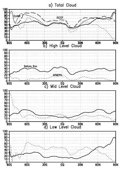
In order to produce realistic DWL data sampling, the nature run cloud distribution should be realistic. A detailed assessment of the nature run clouds is given by M. Masutani, K. Campana and S.-K. Yang of NCEP and S. Wood and D. Emmitts of SWA, and is on display at the OSSE/NPOESS website. The cloud parameterization by Tietke (1993) was used for the nature run.
The nature run clouds are compared with the U.S.A.F.
Real-Time Nephanalyses (RTNEPH, Hamill, 1992) which is
processed at NCEP, the International Satellite Cloud
Climatology Project (ISCCP), stage D2, and the NESDIS
experimental product, "Clouds from Advanced Very High
Resolution Radiometer" data (CLAVR-phase 1). RTNEPH
provides an estimation of the actual amount of high, middle and
low level cloud; ISCCP provides satellite-viewed high, middle
and low level cloud; currently only the total cloud is available
from CLAVR.
Fig.1 Zonal mean of cloud cover for the nature run (solid), RTNEPH (dot), ISCCP (dash), and CLAVR (thin solid). Both over land and ocean are included in zonal average.
Fig.1a shows a general agreement in the zonal mean
distribution of total cloud. The large differences over the north
and south polar region were difficult to evaluate, due to the
difficulties of estimating clouds from a satellite over ice. In all
likelihood, the nature run cloud may be closer to reality than
the RTNEPH estimate and other satellite estimates in polar
regions (R. Grumbine, personal communication). The nature
run high level cloud amounts are much larger than the observed
data and seem more realistic due to the underestimation of high
level cloud in satellite based observation (Fig.1b). Marine
stratocumulus is underestimated especially in mid-latitude, in
this version of the ECMWF MRF model (C. Jakob 1999).
There is also an overestimation of low level cloud over snow in
the nature run (C. Jakob personal communication) (Fig.1d)
These problems in low level cloud require some adjustment.
There is a noticeable difference in the cloud vertical distribution
in tropical convective regions between the nature run and
RTNEPH, but there is no strong observational support to
resolve the differences. Considering the observational
uncertainty in cloud estimates, we judge that, after adjustment,
clouds in the nature run are acceptable for this project.
Adjustment is applied only to the low level cloud based on
ground based observation. (Warren et. al. 1986, 1988)
3. SIMULATION OF CONVENTIONAL OBSERVATIONS
As part of the NPOESS OSSE project, NASA/DAO has the responsibility for the simulation, of realistic conventional observations and satellite observations consisting of cloud motion wind vectors, SSM/I wind speeds and scatterometer wind vectors.
Information from a real observation database is used to
obtain the necessary spatial and temporal distribution to produce
a representative sampling for the simulated observation
database. The initial simulation experiment uses a subset of the
same real observation data set used by the NCEP 40-year
reanalysis project.
3.1 Observing Systems
The real conventional data that are simulated are comprised of observations from surface land stations, ships (both fixed and mobile), buoys (including drifting buoys, platforms and the TOGA TAO array moored buoys), rawinsondes and pilot balloons, aircraft
(both conventional and ACARS) and PAOBS. Both cloud
motion winds and water vapor winds are simulated using real
observations from United States, European and Japanese
polar-orbiting satellites. SSM/I and scatterometer wind
observations are not available in the NCEP 40-year reanalysis
observation data set and therefore are not simulated in the initial
OSSE, but will be included in future OSSE's.
3.2 Observation Simulator
A bi-linear horizontal interpolation and a linear log pressure vertical interpolation are used for the interpolation from the values at nature run grids points to observation points. A simple linear interpolation in time is also performed between the two bracketting six hour nature times to the time of the observation.
Due to differing surface pressures between the real and nature atmospheres, observations using nature surface information is fabricated whenever necessary to preserve near surface upper air observations. For land surface observations, the nature surface pressure is assigned to the station pressure. For ocean surface observations, the sea level pressure is assigned to the station pressure.
Real observations which are available above the nature
atmosphere, that is above 10 mb, are not simulated. Given the
data assimilation system that is being used for the NPOESS,
OSSEs this should not impact the OSSE results.
3.3 Observational error
Uncorrelated random noise is added to perfect simulated observations using a Gaussian normal distribution of numbers along with observation error standard deviations. A set of random Gaussian normal values are generated for each report with the characteristics of having a mean of zero and a standard deviation of one. The observation error standard deviations are obtained from tables produced at ECMWF for each observing system, mandatory pressure level and atmospheric quantity.
Since the observation errors are available at only mandatory levels, significant level errors are obtained by interpolating, linearly in log pressure, the errors at vertically adjacent mandatory levels which bracket the observation to the observation level. For rawinsondes, an additional error is applied to significant level observations.
In the initial OSSE, the only observing system in which
observation error standard deviations are unavailable is ACARS.
Due to the improved accuracy of observations from ACARS
over those obtained from conventional aircraft, conventional
aircraft observation errors would be too pessimistic if applied to
ACARS. Instead, rawinsonde errors are used since rawinsondes
appear to resemble ACARS more closely than any other
observing system with respect to the magnitude of the
observation error.
3.4 Rawinsonde drift error
In addition to the Gaussian error, an attempt is made to
simulate the error incurred by the downstream drift of a
rawinsonde balloon from its launch site. The error is actually
two-fold. An error in sampling may occur as a result of the
horizontal displacement of the balloon from the launch site and
as a result of the horizontal displacement of the column of air
initially existing immediately above the launch site. The latter
source of error is effectively due to the temporal displacement
of the balloon. A simple set of equations has been derived
which takes into account both of these sources of error to
ultimately obtain a single error value at each level for each
measured atmospheric quantity.
3.5 Application of wind error
Wind error standard deviations are directly available in only
component form. However, it is more consistent to apply errors
to wind observations in the form of a direction and speed rather
than as u and v components since wind direction and speed are
the characteristics of the wind field that are measured directly by
conventional instruments. To achieve this, a wind direction and
speed error standard deviation is derived analytically using the
relationship between the directiona and speed and the u and v
components.
4. DWL DATA SIMULATION
Space-based application of Doppler Wind Lidar (DWL) technology is without heritage. Thus, optimal design of DWL systems for space deployment must rely upon simulated experiments. The simulation of DWL data include efforts with DWL performance models, atmospheric circulation models and atmospheric optical models (Atlas and Emmitt, 1995; Emmitt, 1995a; Emmitt and Wood, 1996; Wood et al., 1993; Wood et al., 1995).
The steps between a notional concept for a DWL and the blueprints for instrument construction include a considerable amount of performance modeling and, for space-based systems, an intensive series of OSSEs. During and subsequent to the Laser Atmospheric Wind Sounder (LAWS) study (Baker et al., 1995), a method for assessing the potential impact of a new DWL observing system was established. The instrument parameters are provided by the engineering community. Scanning and sampling requirements are provided by the science community and define various instrument scenarios. These scenarios are tested initially by examining the sensitivity of analyses to the various scenarios. A candidate(s) DWL concept is then chosen for a full OSSE, and an impact study is then conducted and evaluated by a technology neutral group.
The first simulated DWL wind data is produced as the line-of -sight wind by SWA using
their Lidar Simulation Model
(LSM). The configuration of the control experiment is shown
in Table 1. Number of experiments with different resolution
and various assumption regarding cloud characteristics will be
tested.
| Horizontal resolution | 200 km X 200 km |
| Vertical resolution | 1 km above the PBL and 250 m in the PBL. |
| Satellite height | 833 km |
| Nadir scan angle | 45 deg |
| Pulse rate frequency | 12.5 Hz |
Table 1
5. DATA ASSIMILATION SYSTEM AND IMPACT TEST
The data assimilation system at NCEP is based on the "Spectral Statistical Interpolation (SSI)" of Parrish and Derber, 1991, which is a three-dimensional variational analysis (3-D var.) Scheme. In 1995, the assimilation system was modified to use TOVS cloud-cleared radiances instead of using temperature and moisture vertical retrievals, and significant improvements were reported by Derber and Wu (1998). In January 1998, the use of pre-processed radiance data (traditionally referred to as level-1b data) became operational (McNally et al., 1998) and an upgrade to this system was implemented in June 1998. The March 1999 version of NCEP's operational Medium Range Forecast (MRF) and data assimilation system is used for the current data impact test. Line of sight (LOS) winds from DWL are directly used in the data assimilation.
Impacts of TOVS level-1b radiance, RAOB temperature,
and RAOB wind is tested for the nature run period. The initial
experiments are conducted using T62 horizontal resolution and
28 vertical levels. The tests will be repeated with simulated
data. In order to perform reliable OSSEs for future instruments,
the data impact of simulated data for existing instruments must
be similar to that of real data.
6. CONCLUDING REMARK
In addition to a DWL, the Cross track Infrared Sounder
(CrIS), Conically scanning Microwave Imager/Sounder (CMIS),
and the Advanced Technology Microwave Sounder (ATMS)
have been proposed as candidate instrument to be tested by
OSSEs. We are proceeding to develop appropriate forward
models for these instruments.
ACKNOWLEDGMENT
We received much assistance from Keith Fielding, John
Hennessy and John Chambers of Data Services Section of
ECMWF. Informal discussion with Dr. Christian Jakob of
ECMWF was crucial for evaluating the nature-run clouds. Drs.
Roger Saunders and Anthony Hollingsworth of ECMWF
provided generous support towards this project. We would
like thank Drs. Larry Stowe and Andrew Heidinger for
providing CLAVR data. Throughout this project NCEP staffs
provide numerous technical assistance and advice. Particularly
we thank Kenneth Campana, S.-K. Yang, B. Katz, Russ
Treadon, R. Kistler, W.-S. Wu, Song You Hong, Y. Zhu, W.
Collins, Mark Iredel, and D. Keyser. Drs. E. Kalnay, W.
Baker, and R. Daley provided expert advice. We appreciate
constructive comments from members of the OSSE review
panel. This project is sponsored by the Integrated Program
Office (IPO) for NPOESS, and we would like to thank Dr.
Stephen Mango for his support.
REFERENCES
Atlas, R. and G.D. Emmitt, 1995: Simulation studies of the impact of space-based wind profiles on global climate studies. Proc. AMS Sixth Symp. on Global Change Studies, Dallas, TX, January.
Becker, B. D., H. Roquet, and A. Stofflen 1996: A simulated future atmospheric observation database including ATOVS, ASCAT, and DWL. BMAS, 10, 2279-2294.
Baker, W.E., G.D. Emmitt, F. Robertson, R.M. Atlas, J.E. Molinari, D.A. Bowdle, J. Paegle, R.M. Hardesty, R.T. Menzies, T.N. Krishnamurti, R.A. Brown, M.J. Post, J.R. Anderson, A.C. Lorenc and J. McElroy. ,1995: Lidar-measured winds from space: An essential component for weather and climate prediction. Bull. Amer. Meteor. Soc., 76, 869-888.
Derber, J. C. and W.-S. Wu, 1998: The use of TOVS cloud-cleared radiances in the NCEP SSI analysis system. Mon. Wea. Rev., 126, 2287 - 2299.
Emmitt, G.D., 1995a: OSSE's in support of a small-satellite mission. Paper presented at the NOAA Working Group on Space-based Lidar Winds, Clearwater, FL, January 31-February 2.
Emmitt, G.D. and S.A. Wood. Lidar Mapping of Cloud Tops and Cloud Top Winds, 1996. PL-TR-96-2129, F19628-93-C-0196, 1996
Jakob, C. 1999:Cloud cover in the ECMWF reanalysis. J. Climate, 12, 947-959.
Jakob,C. 1999:The rola of vertically varying cloud fraction in the parametrization of microphysical processes in the ECMWf model. Q.J.R Meteorol. Soc., 125, 941-965.
Hamill, T. M., R. P. d'Entrement, and J. T. Bunting, 1992: A description of the Air Force real-time, nephanalysis model, Weather and Forecasting, 7, 288-306.
Henderson-Sellers, A. 1986: Layer cloud amount for January and July 1979 from 3D-Nephanalysis, J. Climate Appl. Meteor., 24, 118-132.
Lord, S. J., E. Kalnay, R. Daley, G. D. Emmitt, and R. Atlas 1997: Using OSSEs in the design of the future generation of integrated observing systems. Preprint volume, 1st Symposium on Integrated Observation Systems, Long Beach, CA, 2-7 February 1997. Posted at the OSSE/NPOESS website.http://nic.fb4.noaa.gov:8000/research/osse
Masutani,M, K. Campana, and S.J..Lord 1999:AMS Preprint volume for the 3rd Symposium on Integrated Observing Systems. 10-15 January 1999, Dallas, TX, 28-31.
Masutani, M. K. Campana, and S.-K. Yang 1999: Note on Cloud Cover of the ECMWF Nature run used for OSSE/NPOESS project. Posted at OSSE/NPOESS website. http://nic.fb4.noaa.gov:8000/research/osse
McNally, A. P., J.C. Derber, W.-S. Wu and B.B. Katz, 1998: The use of TOVS level-1B radiances in the NCEP SSI analysis system. Technical Procedure Bulletin 445, National Weather Service, Office of Meteorology.
Parrish, D. F. and J. C. Derber, 1992: The National Meteorological Center's spectral statistical interpolation analysis system. Mon. Wea. Rev., 120, 1747 - 1763.
Tietke, M. 1989: A comprehensive mass flux scheme for cumulus parametrization in large scale model. Mon. Wea. Rev., 117, 1779-1800.
Tiedtke, M. 1993: Representation of clouds in large-scale models. Mon. Wea. Rev. 121, 3040-3061.
Warren, S. G., C. J. Hahn, J. London, R. M. Chervin, and R. L. Jenne, 1986: Global distribution of total cloud cover and cloud type amounts over the land. NCAR Tech. Note NCAR/TN-273+STR, 29pp.
Warren, S. G., C. J. Hahn, J. London, R. M. Chervin, and R. L. Jenne, 1988: Global distribution of total cloud cover and cloud type amounts over the oceans. NCAR Tech. Note NCAR/TN-317 +STR, 42pp
Wood, S.A., G.D. Emmitt, M. Morris, L. Wood and D. Bai. Space-based Doppler lidar sampling strategies -- algorithm development and simulated observation experiments. Final Rept. NASA Contract NAS8-38559, Marshall Space Flight Center, 266 pp., 1993.
Wood, S.A., G.D. Emmitt, D. Bai, L.S. Wood, and S. Greco, 1995: A coherent lidar simulation model for simulating space-based and aircraft-based lidar winds. Paper presented at the Optical Society of America's Coherent Laser Radar Topical Meeting, Keystone, CO, July 23-27.
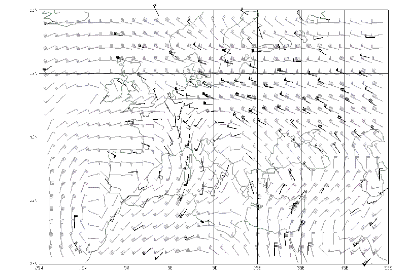
Fig.2 Simulated observed RAOB wind (dark) and wind from the nature run at
500hPa. 12Z 5 February 1993.
Bottom left corner: 26N 25W. Top right corner: 66N 55E. Unit Knots.
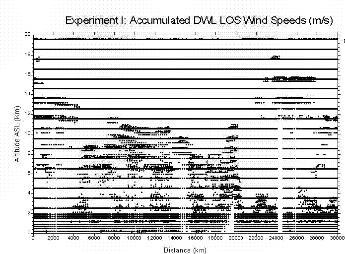
Fig.3 Simulated DWL LOS wind observation along the orbit. Half Orbit of accumulated between 00Z and 03Z on 7th February 1993.